

DEER CREEK, Minn. — The Minnesota Ag Weather Network all started with four weather stations in East Otter Tail County in 2012 as a way to give this area's farmers the data to make important agriculture decisions on their largely sandy soils.
- Is the soil warm enough to plant in?
- What’s the soil moisture at seed depth?
- Is the wind speed too high for effective watering or chemical application?
These are questions the network provides in real-time. And it is data that farmers in other areas of Minnesota want to get their hands on.
ADVERTISEMENT
“Everybody asks, “Why aren’t you in southern Minnesota?’” Minnesota hydrologist and weather station coordinator Stefan Bischof said on Tuesday, Aug. 8, of the station locations. Bischof was one of the presenters at an East Otter Tail County Soil Health Day, west of Wadena, Minnesota.
There are now 24 North Dakota Agricultural Weather Network (NDAWN) stations and 14 Minnesota Department of Ag stations, 38 in all in Minnesota that work together to provide data to users at no cost.
But very soon, more stations will be dotted across all but the northeast corner of Minnesota.
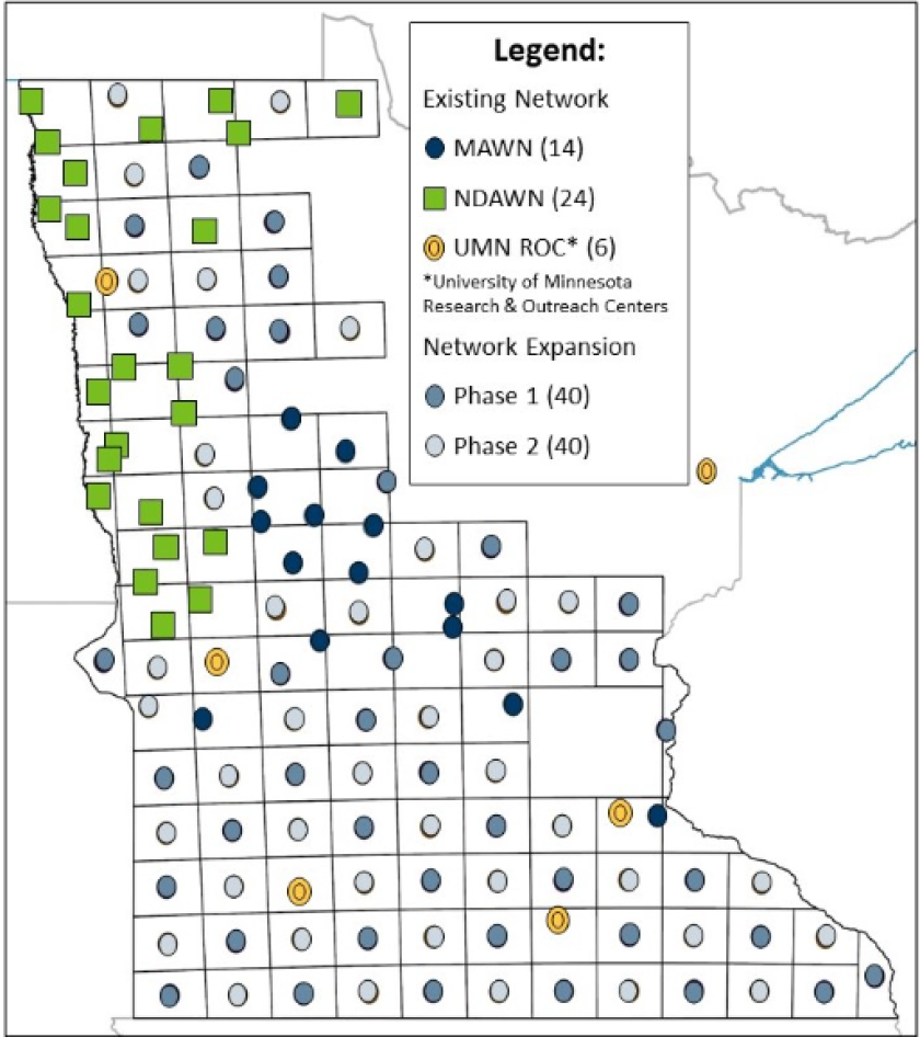
In 2023, the awarded the MDA with $3 million to expand their weather network statewide. That will fund phase I of the project to add 40 new weather stations. Over two phases, they hope to have 80 new stations strung out strategically, each being about 20 miles apart, covering a 20-mile square.


Why Clean Water would fund this project is why this network launched to begin with. Having accurate weather data can help farmers optimize the timing of manure, irrigation, fertilizer and pesticide applications. The goal is that the data would reduce the risk of runoff for those applications, reduce leaching losses to groundwater, reduce pesticide drift, and help reduce uncertainty and risk from adopting new environmentally friendly practices. More accurate data could mean cleaner surface and groundwater.
The initial expansion of approximately 40 additional weather stations will occur in cooperation with several partners over the next two to three years, according to MDA.
Current weather stations cost about $12,000 to install and stand 10-feet tall, but the latest edition will rise 30 feet in the air and cost around $30,000 each. The advantage of the new setup is more instruments across more elevations for more robust data.
ADVERTISEMENT
The stations are capable of measuring rainfall, air temperature, wind direction, wind speed, peak gust, relative humidity, dew point temperature, 4-inch bare soil temperature, and solar radiation.

“We have two sensors at a 4-inch depth. One under turf conditions and one under bare soil conditions,” Bischof said of the soil temperature sensors.
It can also share data to help with crop modeling, daily estimated crop water use, air temperature inversion, disease risk, regional maps of weather data, irrigation scheduling and growing degree days. The most recent stations have moisture sensors that can weigh snowfall and determine the amount of moisture within a snow event. The entire station is powered by a battery that remains charged by a solar panel and all data is communicated by wireless cellular service every five minutes.
Similarly, the
t is at work to expand their reach with a $12.8 million, multi-year project funded by the Army Corps of Engineers and the NOAA Mesonet Program to upgrade, install and deliver data from Mesonet stations to improve operational monitoring of flood and drought conditions.
They plan to have over 150 stations south that every South Dakotan would be within 20 miles of one of a station.
NDAWN has been around since 1989 and has 155 stations across the state and border regions of surrounding states. Since its inception, all NDAWN equipment, non-labor operational costs, and some labor costs have been funded through gifts and grants from various federal and state government agencies, commodity organizations, agricultural clubs, businesses, and individuals. In addition, database/website restructuring was funded through a federal agency grant.
Weather information from the stations is available in real-time (five minute interval) via the website and mobile application. The mobile application is called "NDAWN Inversion" and provides basic real-time weather information and air temperature inversion alerts.
“Which sends out an alert if there is a colder air mass underneath,” Bischof said. That could be conducive to drifting conditions.
ADVERTISEMENT
It is free to download the application at both the App Store (iOS) and Google Play (Android).
Bischof said property owners can contact him if they are interested in getting a station on their property. MDA is also planning to add an application on their website for property owners to apply.
Contact Bischof at Stefan.Bischof@state.mn.us or find out more at .


