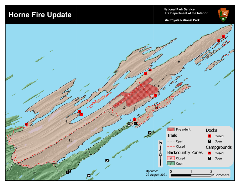
A wildfire ignited the east end of Isle Royale National Park on Sunday afternoon, Aug. 22, covering about 200 acres. The Horne fire, along with ongoing drought conditions and elevated levels of fire danger, prompted park officials to close several areas to the public.
According to a news release from the National Park Service, the following areas have been closed effective immediately:
ADVERTISEMENT
- Lane Cove Trail and Campground.
- Greenstone Ridge Trail East of Mount Franklin Junction.
- Mount Franklin Trail between the Greenstone Ridge Trail and the Tobin Harbor Trail (the half-mile trail section of the Mount Franklin between the Tobin Harbor Trail and Rock Harbor Trail will remain open as conditions allow).
- Duncan Bay Campground and Dock.
- Duncan Bay/Tobin Harbor Portage Trail.
- Duncan Narrows Campground and Dock.
- Tobin Harbor Dock (with the exception of the seaplane dock for the concessions seaplane operation as conditions allow).
- Hidden Lake Dock.
- Hidden Lake Trail and Lookout Louise.
- Merritt Lane Campground and Dock.
- Stoll Trail and Scoville Point.
- Cross-country camping Zones 8, 9, 10, 11, 34, 35, 36 are closed for camping as well as cross-country day use.
Other areas may be closed if fire personnel deem it necessary. The fire status will be continually evaluated as conditions change. The closures will remain in place until rescinded.
Greenwood fire growth slows down
The Greenwood fire in the Superior National Forest remained in the same footprint from Saturday night to Sunday morning. Officials from the Eastern Area Type 2 Incident Management Gold Team credit the light winds and cool temperatures for the slowed growth. The fire remains zero percent contained.
The acreage of the fire has also been reduced to 8,862 acres, or 13.84 square miles, according to infrared mapping. Day and night crews have made good progress on fire-line construction on the southern edge of the fire, according to a report from incident officials.
Fire officials also scouted new areas to hold the fire to the west and north of Highway 2 after Friday evening's four-mile run. Firefighters are taking measures to protect homes around Sand Lake and Highway 2, McDougal Lake and in areas to the north where there was fire growth. The fire is expected to grow mainly on the northern edge, with temperatures 20 degrees lower and patchy fog helping to slow fire activity.
A public meeting will be held at 6 p.m. on Monday, Aug. 23, at the Wolf Ridge Environmental Learning Center for the Greenwood fire, Superior National Forest fires and the Boundary Waters Canoe Area Wilderness closure. The U.S. Forest Service, Lake County Sheriff's Office and Incident Command Team will share information. The meeting will also be broadcast live on the Superior National Forest Facebook page.
ADVERTISEMENT
Other fires in the Superior National Forest
The John Ek fire was kept in its current footprint Saturday with lower temperatures and suppression activities via aircraft. It is estimated to be 727 acres 2.5 miles south of Little Saganaga Lake and extends from John Ek Lake to the southeast corner of Elton Lake. Fire-suppressing aircraft will continue to drop water on the fire.
The Whelp fire, five miles west of Sawbill Lake, continues to creep and smolder without moving outside its footprint of 50 acres. Fire-suppressing aircraft will continue to drop water on the fire. No firefighting crews have been sent in due to difficult access.
Closures
Highway 2 is closed from Forest Highway 11 to Highway 1. Highway 1 is closed from New Tomahawk Road to Lankinen Road.
A Forest Service closure order is in place that extends across the Kawishiwi, Laurentian and Tofte ranger districts and a small portion of the Boundary Waters Canoe Area Wilderness. For more information, go to .
A temporary flight restriction for aircraft is in place over the fire area.